VVMapping.com - providing high quality mapping products for outdoor recreation

You are here -> Home: Trail Info: Pioneer

Home

Free Maps

Store

ORV Trail Maps

Snowmobile Trail Maps

Outdoor Recreation Maps

Service/Support

Contact

Privacy Policy

About Us

Mailing List


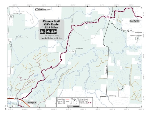
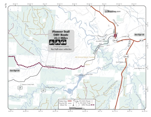
Information on Pioneer Trail ORV Route

Back to Main Trail Info Page

OHMATV

Pioneer Trail
Pg# (PDF)
Width: 65"
Length: 22.3
Traffic: Little
County Rds Open to ORVs: Yes
Forest Rds Open to ORVs: Some
Restricted ORV Route. Uses Ottawa National Forest Land and some private property sections. Some sections are not open to full size vehicles.Trail is primarily snowmobile trail #13. Rocky/hard packed and can be muddy with some small elevation changes. New in 2012. Located in Ontonogan County which allows ORVs on their roads. Forest roads generally open as well with restrictions in National Forest. Closed March 15th through May 15th.

** The Ottawa National Forest lists this "trail" as open to non-highway licensed vehicles. Effectively they are restricting full size vehicles from it, allowing motorcycles, ATVs and UTVs.**

Back to Trails List

Information about this page

Information regarding ORV use in Michigan

Trail Guide at a glance

Big Picture of trail locations

Map Book Information

GPS Map Information

Creative Commons License
This work is licensed under a Creative Commons Attribution-Noncommercial-No Derivative Works 3.0 License

Email Webmaster@vvmapping.com for site issues/suggestions
Email info@vvmapping.com for all other items

Copyright 2008 Valley Ventures Mapping LLC