VVMapping.com - providing high quality mapping products for outdoor recreation & Beyond
|
|
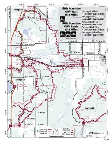
Information on Little Manistee ORV Trail
Little Manistee ORV Trail, motorcycle-only. Sandy trail, flat to rolling. Several loop options. Connects to Lincoln Hills ORV System, Little O ORV Trail. Staging areas, modern at Carrieville. Connects to food at M-37; fuel at Carrieville. Connects to Carrieville State Forest Campground and North Country Campground. Staging areas, Carrieville is modern. See also Little Manistee Route. Located in Lake county which allows ORVs on some roads.
Video of Trail (video by Brett L). 1 Minute, Flash v8 video, 4MB
|
Back to Trails List
Information about this page Information regarding ORV use in Michigan Trail Guide at a glance Big Picture of trail locations Map Book Information GPS Map Information
|