Trail
Notes:
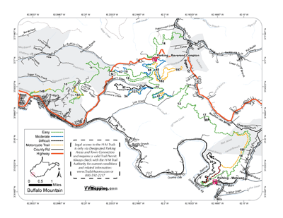
38 Black
From 39 to 18. Minor descent. Easier 39 to 18.
39 Extreme
From 18 to 38. Several steep/rocky climbs, some narrow. Easier
38 to 18.
92 Black
From 34 to 15. Significant descent, some loose rocks. Easier
34 to 15.
98 Black
From 16 to 13. Rocky climb and rocky descent. Same either
way.
199 - Rode 1/2 of trail including both ends, not actual track between;
did not ride all.
198 - Easier 38 to 195; serious rock steps/descent at 195.
197 - Did not Ride; not actual track
196 - Easier 20 to 48, couple interesting rocky climbs, lots
of narrow/edge sections.
195 - Rode 1/4 mile each end, significant rocky steps/climbs/descents.
186 - Did not ride; not actual track
182 - Rode each end, about 1 mile total. Several step-out
rocky/rooty ledges and descent ledge climbs.
150 - Easier 18 to 21; major descent at 18 end.
132 - Easier 11 to 10 for minor sidehill descent at 10; hop
pipeline with some rocks and tight trees.
56 Blue - Lots of switchbacks from 57 to 11, downhill all
the way.
57 Blue - Decent rocky climb; easier 56 to 11.
96 Black - Downhill from 11 to 94.
94 Black - Long descent from 96 to halfway; then road up
to 95; easier 96 to 95.
95 Black - Decent rocky climb from 94 to 11; easier 11 to
94.
99 Black - Serious descent from 23 to 35; easier 23 to 35.
90 Black - long switchback rocky climb near 29 Blue.
97 Extreme - vertical drop to connect to 18 Green.
149 Orange - several off camber climbs counterclockwise.
147 Orange - slick off camber climb counterclockwise.
177/178 Orange - substantial climb in either direction, trail currently drops into cut in between access road and mountain side where the DEEP mud is (yuck for the bike!).
191 Orange - Short but substantial drop from 198 to 18.

