![]()
Documentation, Help and How Tos
GPS Settings for Routing Functions
Need Help? Call or Email: (989)-751-6863 or help@vvmapping.com
Jump to:
Our routable maps are designed to work with the default routing settings across the widest range of models from Garmin. This works great for most of the models, though there are some that require additional settings changes on the GPS to work well.
There are several settings to get the best experience with the routing as shown below. Our maps include the ability to route across the trails, county roads, forest roads as well as highways and interstates.
The suggested Route the GPS develops may or may not be legal depending on the vehicle and area you are in - keep that in mind when the GPS is providing suggestions to you.
Routing Preference/Priority:
Snowmobile Maps: The Snowmobile Trails as the best/fastest route, the county roads, USFS Roads then highways and interstates.
Great Lakes ORV Maps: ORV Routes and ORV Trails, then ORV-open roads that are also Snowmobile Trails, then ORV-open forest roads, ORV-open secondary town/county roads and finally ORV-open primary county roads and highways. Motorcycle trails are given lowest priority. Roads that are not open to ORVs are also marked as Toll Roads. 50" ORV Trails are also marked as Unpaved Roads.
Appalachia ORV Maps:ORV Systems with a difficulty rating give priority to easier trails (green, blue) and lower to more difficult trails (black/read/orange).
Important information: The trails on our maps are actually highways, or so the GPS believes. The GPS must be set to use highways and fastest time to have it route using a trail.
The real highways are also toll roads, thus if you want to avoid routing using State/Federal highways, you can enable the toll road avoidance option available in many of the models.
Very important: If you configure the GPS to use a mode/profile like "off road" or "trail" or to avoid highways, the GPS will NOT use the trails and will only use county roads and highways.
Even more important: DO NOT BLINDLY FOLLOW THE GPS! Look at the map screen, plan your trip. Determine where you need to go to reach the trails. There are times where the GPS has no connection except to a highway which it then must follow for miles before the trail crosses that highway. Just across that highway from your position may be the trail and so crossing the road would let the GPS give more realistic guidance.
Routing settings for Snowmobile: Faster Time, Avoid "Toll Roads" and no other avoidances.
Routing settings for Great Lakes ORV: Faster Time, Avoid "Toll Roads"; Avoid "Unpaved Roads" if you want to avoid 50" ORV Trails in MI and MN; no other avoidances.
Routing settings for Appalachia ORV: Faster Time, Avoid "Toll Roads" and no other avoidances.
Nuvi and similar models (older Zumo):
Check the System settings to ensure the GPS is configured for Driving or Highway Mode under the Navigation settings. Screen may appear slightly different depending on model, the basic options to reach and set the settings are generally the same. Out of the box, most Nuvi models will work without modification. The following items will make it work better.
Next check that the Routing or Navigation setup is configured to best use our maps. We want to disable all avoidances except Toll Roads and set the Preference for Faster Time.
Tools -> Settings -> Navigation. Set Faster Time and the Avoidances to only include Toll Roads. Note if you do not disable "U Turns" the GPS will sometimes draw a route hundreds of miles out of the way just to reach a trail that is less than a mile behind you; if Highways are disabled, the GPS will not route on the trails.
Also see Map Setup under GPS General Settings.
Newer Nuvi, Drive and similar models (newer Zumo):
Check the System settings to ensure the GPS is configured for Driving or Highway Mode under the Navigation settings. Screen may appear slightly different depending on model, the basic options to reach and set the settings are generally the same. Out of the box, most Nuvi models will work without modification. The following items will make it work better.
Make sure to disable other maps. This includes one of our Snow & ORV combo maps; see GPS Settings for info.
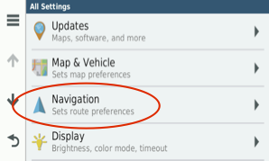
When the unit powers up, choose Settings from the main screen.
Tap on Navigation:
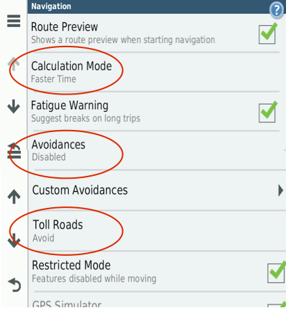
Tap Calculation Mode and set it to Faster Time.
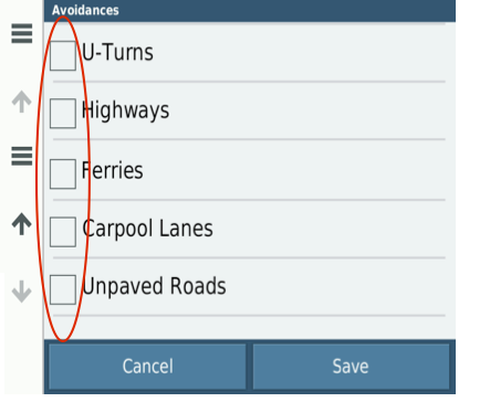
Tap Avoidances and set it to there is nothing checked (next image).
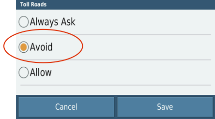
Tap Toll Roads and set to Always Avoid (2nd image)
Some models of the Oregon line require the GPS to be put in Road/Highway mode as they arrive in off-road mode.
The Oregon supports "profiles" that allow you to quickly switch between modes, making the GPS setup to better handle the task you want to use it for. Change the profile to "Automotive".
Setup -> Profiles -> Automotive
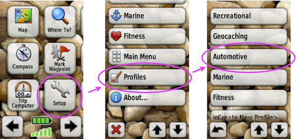
Set the Routing preferences to be On Road for Time, Calculate for Car/Motorcycle, Lock on Road (yes) and Avoidances will just be Toll Roads.
Also see Map Setup under General GPS Settings for the Oregon.
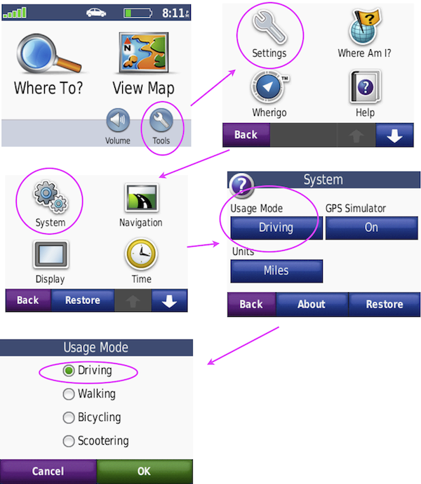
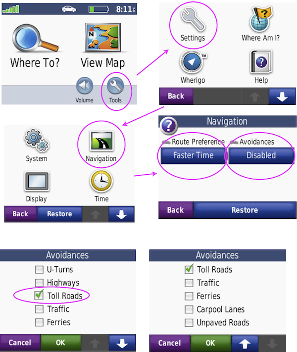
Routing Setup on Montana units - recommended settings for optimal use.
Changing these settings ensures the unit is setup for trail-based routing.
DO NOT USE "off road" mode or profile - our maps are designed as automotive/highway routing. The snowmobile/ORV trails are setup as "highways".
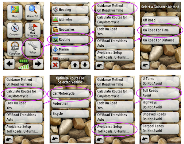
Power on the unit.
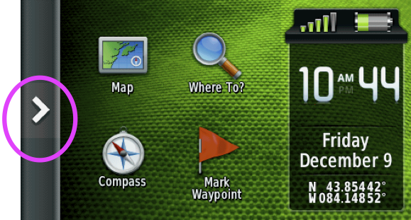
Tap the chevron to access the main menu.
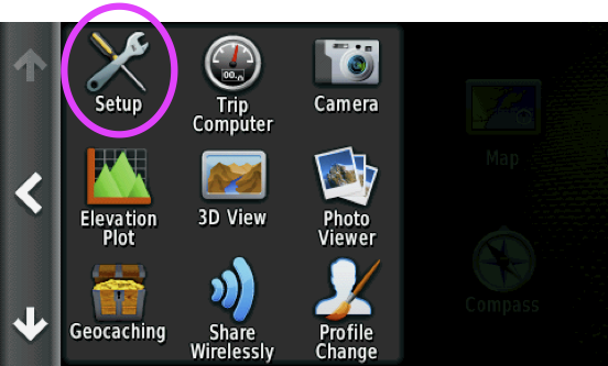
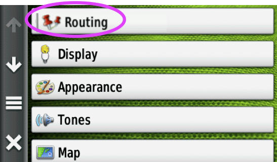
Tap "Setup"
Tap "Routing"
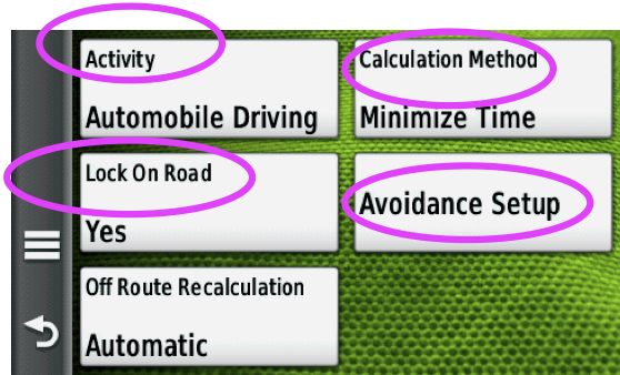
Set Activity to "Automobile Driving", Calculation Method to "Minimize Time" , Lock on Road to "yes". Tap Avoidance Setup.
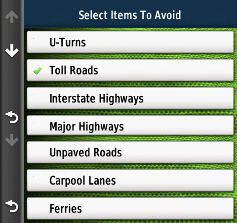
Disable all avoidances except for Toll Roads or allow all avoidances except for Toll Roads.
This will tell the GPS to use any of these options EXCEPT "Toll Roads".
Our maps treat the trails as highways, so we want them enabled. The actual highways are treated as "toll roads" so avoiding them will have the GPS try to avoid any state/federal highways.
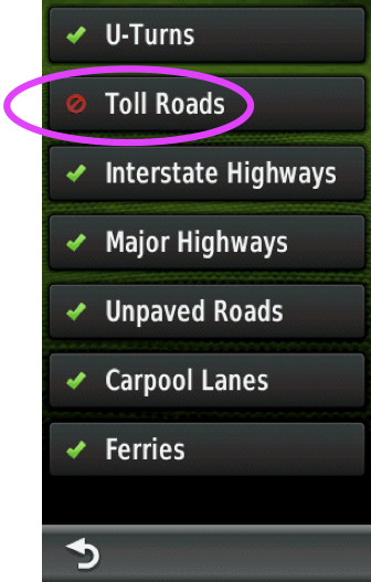
Garmin has two versions of the avoidance screen, older models have you check the box for items to allow, newer have you check a box for items to avoid. Look at the top of the screen and see what the instructions say. The older version has a circle-with-a-slash symbol and a check mark, with the check mark meaning to allow the item.
Newer version of Montana:
Older version of Montana:
Routing Setup for 60c/CX/CSX - recommended settings for optimal use.
Routing settings for a 60 series unit is under Routing, under Setup in the Main Menu.
Press the Menu button twice to reach the Main Menu or press the Page button until it changes to the Main Menu.
Select Setup and press Enter
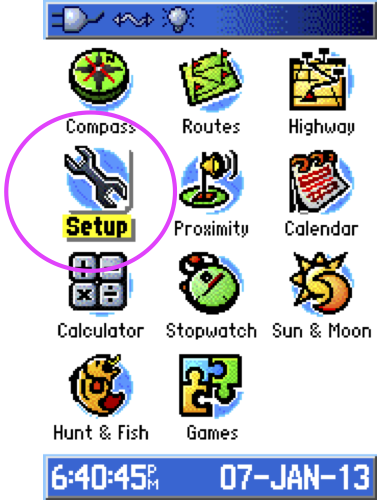
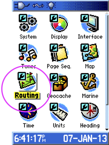
Select Routing and press Enter
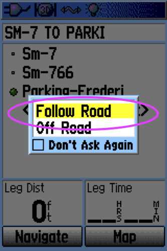
Change the settings to "Follow Road", "Faster Time". Select "Follow Road Options and press Enter.
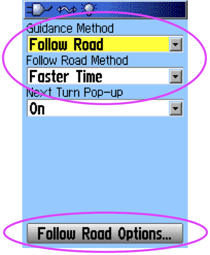
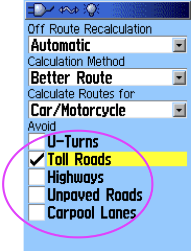
Toll Roads should be enabled as an avoidance, the rest should be off.
That's all for the settings on the 60.
When starting a Route, select "Follow Road" if given the choice. This setting is also in the Routing Setup options.
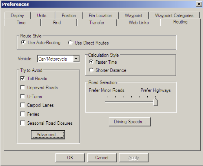
Routing Setup in MapSource - recommended settings for optimal use.
Automotive mode
Fastest Time
No avoidances except Toll Roads
AutoRouting, not off-road.
In MapSource, choose Preferences from the Edit menu
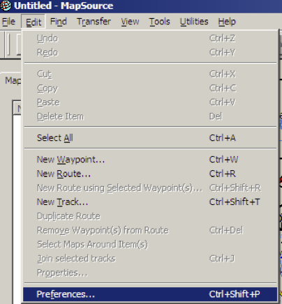
Click on the Routing tab and then set as below.
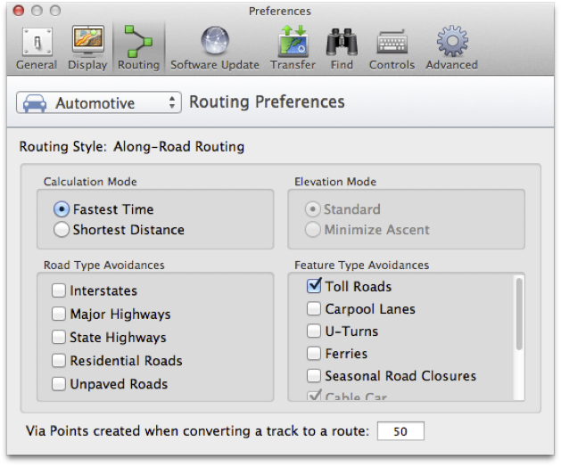
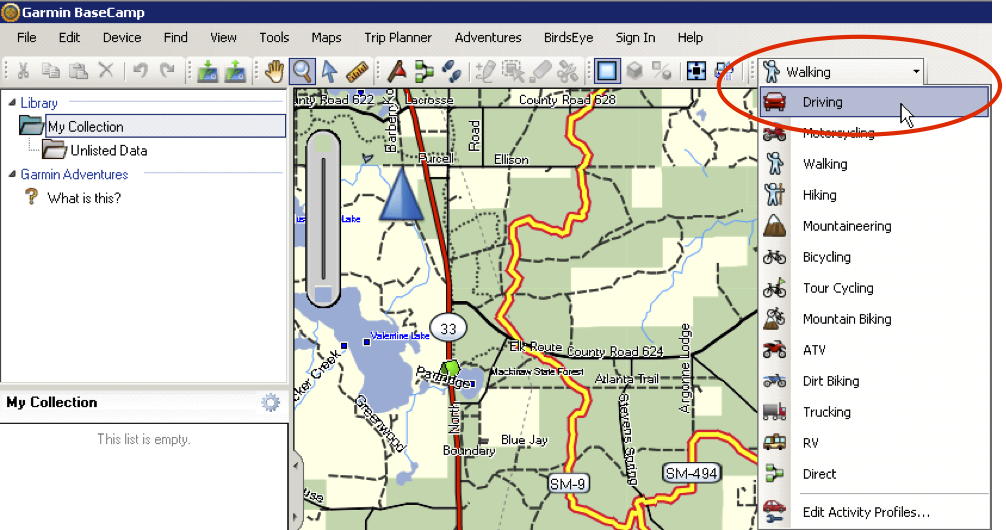
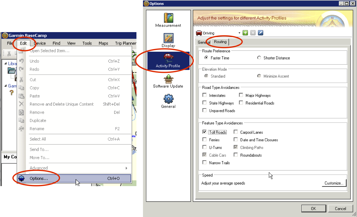
Routing Setup in BaseCamp - recommended settings for optimal use.
Automotive mode
Fastest Time
No avoidances except Toll Roads
AutoRouting, not off-road.
Windows Version:
First, set your activity profile to Driving.
Note you can choose another profile type and then customize, but we suggest driving to keep it consistent.
Next, set the options for that activity (Driving). This only needs set once.
Choose Options from the Edit menu.
Click on Activity Profile in the left column, then click on the Routing tab on the right side.
You want "fastest time", no road type avoidances and only "Toll Roads" for feature type avoidances (note some types may be greyed out that you can't change).
Macintosh Version:
In BaseCamp, choose Preferences from the Apple menu:
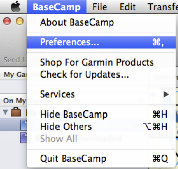
Click on the Routing icon and then set as below